Targeting Q4 2023 to begin maiden drill program.
Lithium King Project, Utah
Upcoming Catalyst
Localisation
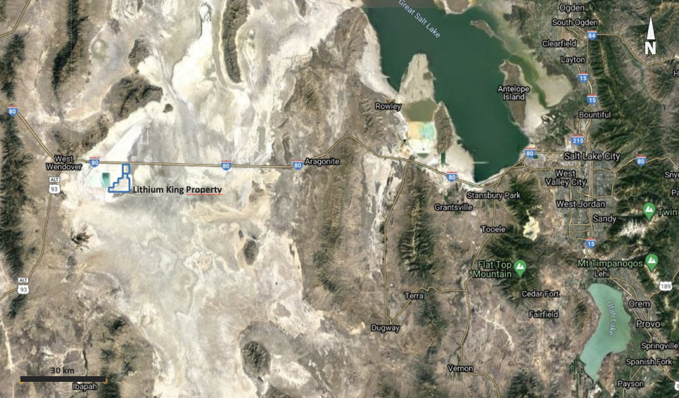
The project is located 170km West of salt Lake City along Highway 80.
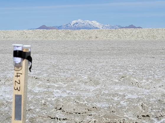
Claim post on the Lithium King Property
Exploration
The project area is located within the limit of the paleo Lake Bonneville. Lake Bonneville was the largest Late Pleistocene paleolake in the Great Basin of western North America. The Western Interior Seaway preceded Lake Bonneville. It was a pluvial lake that formed in response to an increase in precipitation and a decrease in evaporation as a result of cooler temperatures. The lake covered much of what is now western Utah and at its highest level extended into present-day Idaho and Nevada.
Beneath the Lake Bonneville beds are several hundred meters of unconsolidated earlier Quaternary fluvial and lacustrine sediments, in places resting on late Tertiary tuff and fresh-water limestone. Precambrian, Paleozoic, Mesozoic, and Cenozoic sedimentary, metamorphic, and intrusive and extrusive igneous rocks are exposed in the mountains adjoining and within southern Utah Valley. These rocks were the source of the sediments now in the valley.

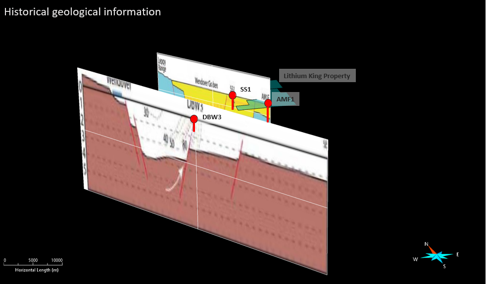
Historically, three oil wells have been drilled by Shell and Alpha Minerals in the vicinity of the Property.
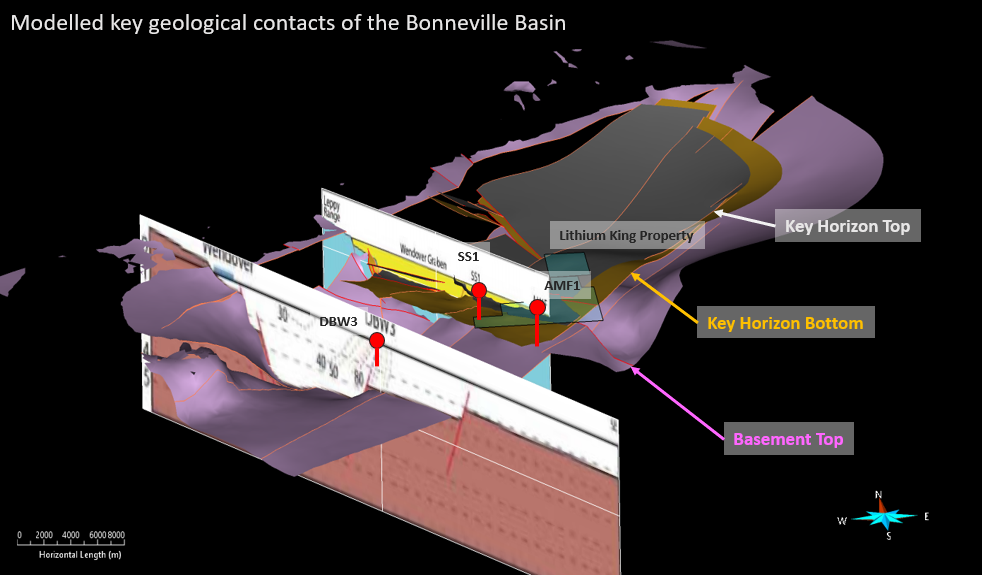
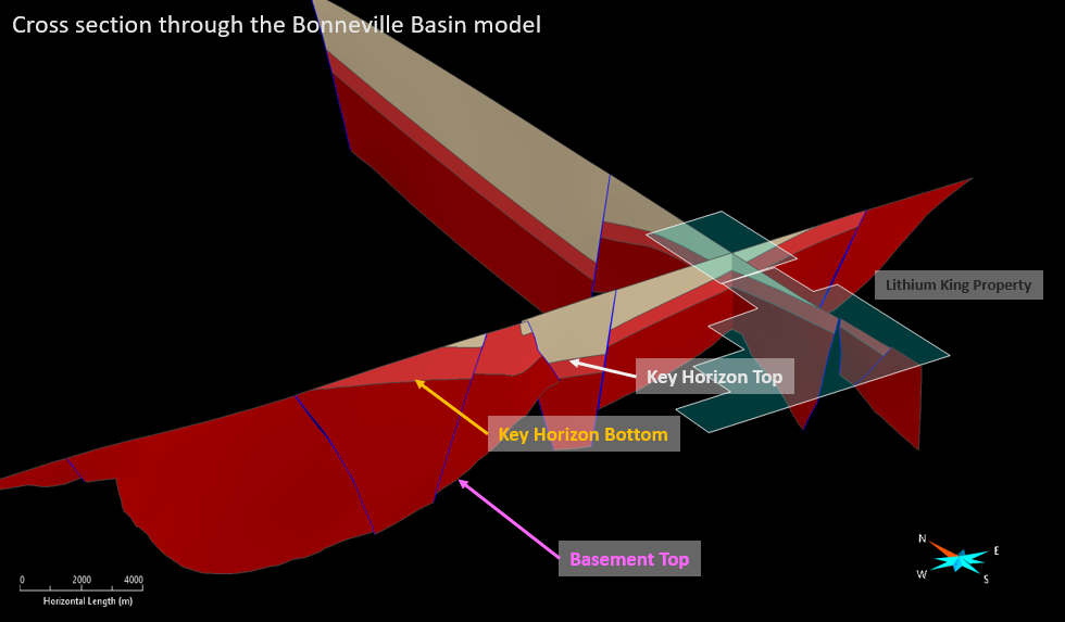
The well locations together with the interpreted cross section and surface geological interpretation enabled GBML to construct a preliminary 3D model of the basin.
Geological Setting
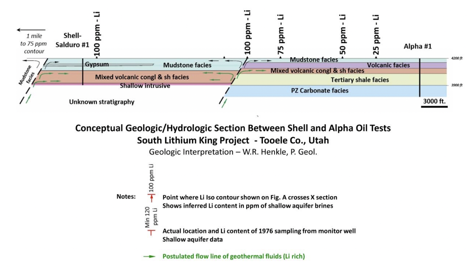
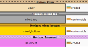
The geological logs from the historical oil well were used to establish a schematic stratigraphic column for the Bonneville lake basin.
The stratigraphy comprises deposits associated to the Bonneville Lake overlying unconsolidated earlier Quaternary fluvial and lacustrine sediments, in places resting on late Tertiary(?) tuff and fresh-water limestone.
The stratigraphy suggests the presence of several potentially impermeable unit that might segregate the basin brines at different stratigraphic levels.
The presence of subsidence faults also suggest pathways for deep brines up flow, potentially explaining higher Li content in surface samples.
In the project area vicinity, the estimated basement depth (Paleozoic rocks form basement) varies from 700m to 1,200m vertical*.
The top of the interpreted key porous horizon (mixed volcanic conglomerate and shale of Tertiary age) is estimated to be located at a depth of 150m with a possible thickness of 200m*.
The project is also located near 2 major basin faults associated to a local sub graben (blue lines). Current water temperatures also indicated possible deep basin fluid upwelling along those faults*.
To the North of the Property, a set of E-W faults associated to a graben into the Pilot Range could also present a source for basin fluids*.
Exploration Potential
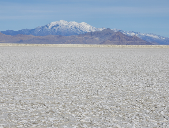
The Lithium Property is located South of the Pilot Valley, at the Western margin of the Bonneville Salt Flats.
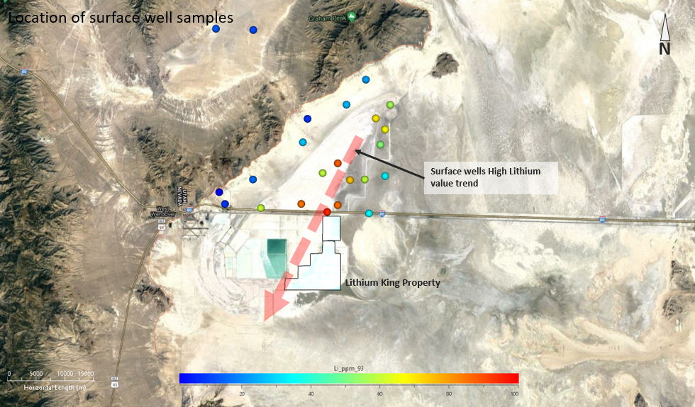
Historical surface water sampling from shallow drill holes (0-25 feet) by the USGS between 1972 and 1993 (U.S. Geological Survey Professional Paper 1585) identified anomalous Lithium values ranging from 2 ppm to 1,200ppm*.
The Property sits along the Southern extension of an interpreted high Lithium value trend from the surface well samples*.
Geophysical Data
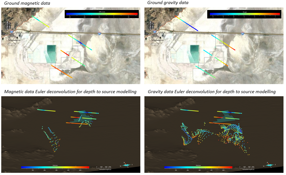
Four (4) lines of ground gravity and ground magnetics were acquired as part of the initial exploration work conducted in 2021.
The processing of the geophysical data together with the geological data are used as input to conduct a preliminary 3D model interpretation of the basin’s structure and stratigraphy.
The geophysical data and geological historical information were used as constraints for the construction of a basin 3D model comprising 3 key horizons.
Mineral Potential
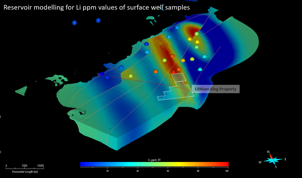
The interpretation of the key horizon* was used to generate a reservoir model in which the surface water sample values for Li ppm** were extrapolated.
The position of the project area in regards of the higher surface water Li values shows the potential for Lithium enriched brines at reasonable depths of 200-500m*.
*Surface water samples may not reflect the basin brine’s composition and drilling with brines sampling is needed to confirm the presence of Lithium in the basin brine
In order to assess the Lithium potential of the basin brines on the Lithium Property, the following work will be conducted by GBML:
1. Locate and digitize existing Oil well data to help in the modelling of the basin - COMPLETED
2. Acquisition of public domain geophysical datasets. This will help in improving the subsurface structural and geological model. A depth to basement modelling exercise shall be conducted. The data should include, but is not limited to: COMPLETED
-
Gravity
-
Magnetics
-
Seismic
3. Exploration mud rotatory drilling with wireline geophysics to evaluate the stratigraphy and basement depth for the Property area
4. Water sampling of drill holes using in-hole packer equipment to test for Lithium enrichment and deleterious element content of the brine
5. Further geophysical data acquisition to assess basement depth, water content and brine depth throughout the basin. This will be conducted by a combination of gravity and EM data acquisition
6. Further drilling to test for:
-
Stratigraphy
-
Brine composition
-
Production metrics